

-
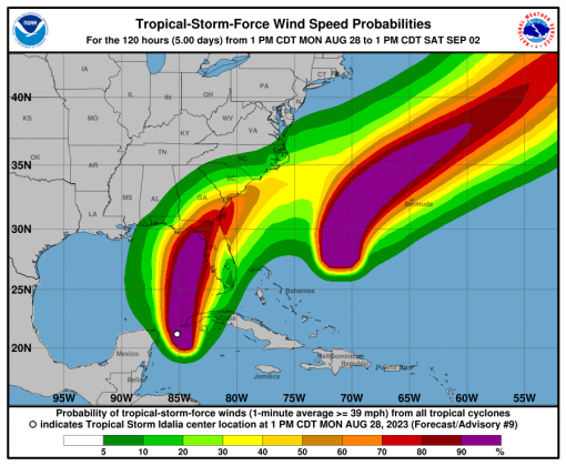 The NHC chances of tropical storm-force winds. Osceola County is just under 40 percent.
The Tropical Storm Watch issued for Osceola, Orange and Seminole counties Monday morning was upgraded to a Tropical Storm Warning at 5 p.m., meaning those conditions — winds of 40 mph, are now EXPECTED sometime in the next 36 hours thanks to soon-to-be Hurricane Idalia.
For us, that's from Tuesday evening through Wednesday afternoon. The National Hurricane Center's wind probabilities for the Orlando area in the 5 p.m. guidance package were 39 percent of winds of at least 40 mph, and a 7 percent chance (1 in 13) of 58-74 mph winds, through Thursday.
The National Weather Service in Melbourne, tasked with issuing these warnings to inland areas — the Hurricane Center does the coastal areas — lists "Peak Wind Forecast: 20-30 mph with gusts to 45 mph" for Osceola County. The rain threat remains at 1-3 inches with "limited potential flood impacts."
With that said, it's probably a good idea – TONIGHT, or at least by early Tuesday morning — to secure outdoor items that can become wind-bourne, like patio furniture, toys, canopies, trash cans and the like.
On the current projected path, THIS IS A DIFFERENT STORM THAN HURRICANE IAN OF LAST YEAR. Nonetheless, it is important to keep up with it, here at AroundOsceola.com, the NWS Melbourne or NHC.
The NHC projected path of movement still brings Tropical Storm Idalia, expected to become a hurricane tonight and a major hurricane by Tuesday, into the Big Bend area of the west coast of Florida as a Category 3 storm with 120 mph winds in the Wednesday morning hours just after daybreak.