

WE NEED TO WATCH THIS CLOSELY in Osceola County.
-
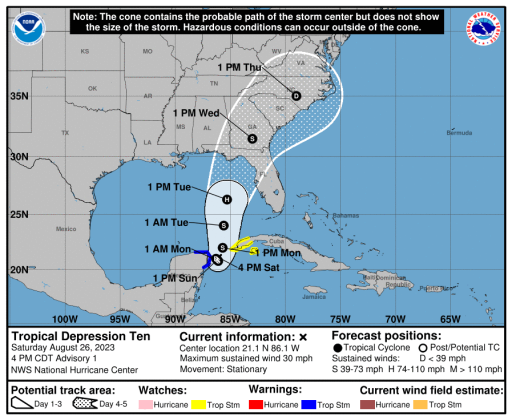 The first NHC cone of uncertainty is just west of Osceola County. Residents are urged to stay informed of updates. NHC
The National Hurricane Center began issuing advisories on Tropical Depression 10 at 5 p.m. Saturday.
While it's off the coast of the Yucatan Peninsula and barely moving, it's expected to begin moving north toward the eastern Panhandle and Big Bend portions of Florida on Monday, and reach the coast Tuesday night into Wednesday as a hurricane. The next storm name is Idalia. (ee-DALE-ya).
The right edge of the "cone of uncertainty" goes right up I-4, meaning WE NEED TO WATCH THIS CLOSELY in Osceola County. We will be to the east, or right, of the intensifying storm ... the "dirty" side, meaning fast-moving feeder bands with intense thunderstorms and tornadoes are possible.
This is the first advisory package, meaning the expected track will become more refined. Any shift eastward in the track could lead to more impacts. Stay tuned to AroundOsceola.com, the NHC and other reliable local sources like the Osceola County Office of Emergency Management.
Take advantage of the tax-free holiday and get supplies ahead of the storm's impacts.
INTERESTING NOTE: The NHC uses six naming lists they rotate. This year's list was last used in 2017. The 'I' name, Idalia, was added to the 2023 list after a certain 'I' storm's name was retired in 2017. Of course you remember Hurricane Irma ...