

Biggest threat for Osceola County today? Heat indexes approaching 105
-
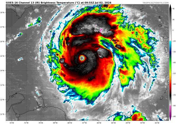
Beautiful and deadly Hurricane Beryl, a Category 5 storm as of 11 p.m. PHOTO/TROPICAL TIDBITS
Beautiful and deadly Hurricane Beryl, a Category 5 storm as of 11 p.m. PHOTO/TROPICAL TIDBITS -
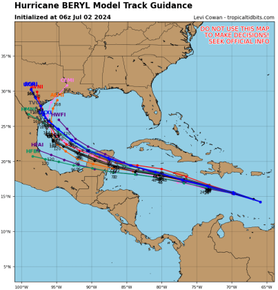
Hurricane computer models are in tight agreement that Beryl will track very close to Jamaica Wednesday, hit the Yucatan Peninsula Friday as a weakening storm, then enter the Gulf of Mexico. GRAPHIC/TROPICAL TIDBITS
Hurricane computer models are in tight agreement that Beryl will track very close to Jamaica Wednesday, hit the Yucatan Peninsula Friday as a weakening storm, then enter the Gulf of Mexico. GRAPHIC/TROPICAL TIDBITS
After slamming into Carriacou Island in the Grenadines as a Category 4 hurricane with 140 mph maximum winds, Hurricane Beryl was upgraded at 11 p.m. Monday to a deadly Category 5 hurricane.
Beryl is now the earliest Category 5 storm to form in recorded history, beating Hurricane Emily (July 17, 2005).
The 8 a.m. advisory, fed by data from Hurricane Hunter reconnaissance flights into the classically-built storm, noted the storm packs 165 mph winds and an impressive 934 millibar central pressure as it heads in the general direction of Jamaica and the Cayman Islands.
With the storm moving west-northwest at a brisk 20 mph, the National Hurricane Center forecasts the potentially deadly center of Beryl to be just south or very near the southern coast of Jamaica around midday Wednesday, still a Category 3 major hurricane, and near or crossing the Yucatan Peninsula of Mexico on Friday. After that, land interaction should weaken it to a tropical storm. After that, long-range models show a potential track toward south Texas after the weekend.
"There is still increased uncertainty in the track forecast beyond 72 hours, with the model guidance showing a large spread as Beryl emerges over the Gulf of Mexico," the NHC's 5 a.m. storm discussion read. A new forecast envelope will come out at 11 a.m.
Jamaican officials, who issued a hurricane warning Monday, are telling residents to "Take this storm very, very seriously" as impacts could be potentially catastrophic, especially on the island's south coast. Tropical Storm Watches have become warnings along the southern coast of Hispaniola, and a Hurricane Watch is now in effect for the Cayman Islands.
In Osceola County, the biggest weather impacts Tuesday and Wednesday will be high heat indexes. While high temperatures won't get much past 90, high humidity will make it feel like up to 105 degrees in our area. The only relief is potential afternoon thunderstorms, normal for this time of year, by the late afternoon.