

-
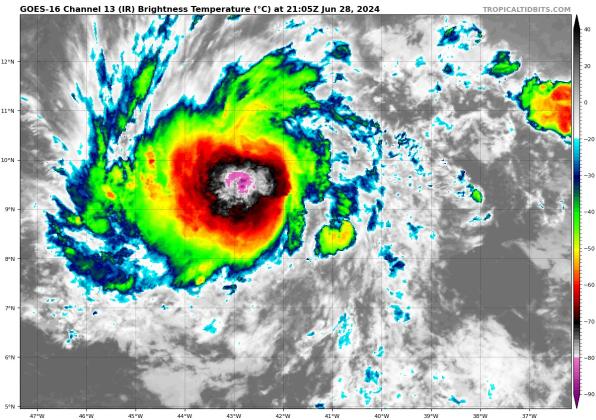 A tropical wave in the eastern Atlantic ocean was upgraded to Tropical Depression 2 by the National Hurricane Center Friday afternoon. PHOTO/TROPICAL TIDBITS
 -
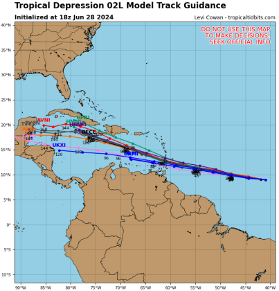 Long range models for Tropical Depression 2, soon to be Tropical Storm Beryl. GRAPHIC/TROPICAL TIDBITS
FRIDAY 11 P.M. UPDATE -- The National Hurricane Center classified Tropical Depression 2 as Tropical Storm Beryl at 11 p.m. Pretty much everything, including the forecast track and downstream intensity, remain the same from the 5 p.m. advisory.
The second tropical depression of the year has formed in the eastern Atlantic; while tropical weather experts say this type of development this far east is "early", the National Hurricane Center said hurricane and tropical storm watches for the Leeward Islands may be posted tonight as Tropical Depression 2 is expected to develop into Tropical Storm, then Hurricane Beryl.
"Typically, the atmospheric environment is unfavorable for intensification in this portion of the Atlantic basin in late June," NHC forecaster John Cangialosi said in the first TD2 storm discussion. "However, the overall atmospheric and oceanic conditions appear conducive for steady strengthening during the next few days."
As of the first set of advisories Friday at 5 p.m., TD2 was located 1,225 miles east of Barbados in the Lesser Antilles, most west at 17 mph. The NHC had been monitoring the tropical wave it developed from since Wednesday. It could become Beryl at 11 p.m. or in one of Saturday's advisories. The current forecast is for the storm to reach the islands as a Category 2 hurricane with potential maximum sustained winds of 100 mph.
The five-day projection, which the NHC warns that "Users are reminded that there is large uncertainty at days 4 and 5 and to not focus on the specific details of the track or intensity forecast," has the storm weakening to a Category 1 as it could approach Jamaica by Wednesday. That follows long-range computer models that keep the storm south of Cuba in seven days time, thanks to strong subtropical ridge to the north of the system. It is still FAR too early to tell about the impacts possible anywhere on the Gulf coast.
Another wave is east of TD2, moving along with it, and give it a 30% chance of developing into a depression in the next seven days, although it may be hindered in that by its proximity to the strengthening TD2. And, a wave currently east of the Yucatan Peninsula has the same 30% chance to become a depression before moving westward into central Mexico.
We'll keep tabs on all of it here at AroundOsceola.com!