

-
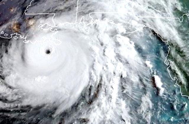
PHOTO/COLORADO STATE UNIV. Hurricane Dorian roars through the Bahamas as a Category 5 storm on Sept. 1, 2019. The Colorado State University tropical analysis research team predicts 20 named storms will form in the Atlantic basin during the 2022 hurricane season.
PHOTO/COLORADO STATE UNIV. Hurricane Dorian roars through the Bahamas as a Category 5 storm on Sept. 1, 2019. The Colorado State University tropical analysis research team predicts 20 named storms will form in the Atlantic basin during the 2022 hurricane season.
Following the lead of the last two extremely active hurricane seasons, leading hurricane researchers say 2022 will be more of the same.
After an mindboggling 51 named storms formed combined in 2020-21, researchers with the Colorado State University hurricane research team have increased their initial forecast made in April and now predict a well above-average Atlantic hurricane season in 2022.
They now predict 20 named tropical storms will form this year — that would take us to the ‘V’ storm — with 10 becoming hurricanes and five ascending to major (Category 3-5 with maximum sustained winds of 110 mph or more) status.
That 20-10-5 prediction update, made June 2, is bumped up a tick from the 19-9-4 forecast made in April.
Why? Warm tropical waters and an expected La Niña weather pattern.
“The odds of El Niño for this year’s hurricane season are now quite low, and the odds of La Niña conditions have increased relative to what was projected,” CSU lead researcher Phil Klotzbach said.
The tropical eastern and central Pacific currently has weak La Niña conditions; that is, the water temperatures there are somewhat below average. Researchers believe El Niño, which causes and increase upper-level westerly winds across the Caribbean into the tropical Atlantic, tearing apart hurricanes as they try to form, is very unlikely.
Furthermore, the tropical Atlantic Ocean is currently is warmer than normal, while the eastern Atlantic from the subtropics to the mid-latitudes is much warmer than normal. This type of sea surface temperature configuration tends to force a weaker subtropical high and associated weaker winds blowing across the tropical Atlantic. These conditions then lead to warmer waters in the tropical Atlantic for the peak of the Atlantic hurricane season, which is generally mid-August (Hurricane Charley rolled through Osceola County on Aug. 13, 2004) through early October (Hurricane Jeanne, the caboose of that year’s hurricane train, rumbled through on Sept. 25, 2004).
“So far, the 2022 hurricane season is exhibiting characteristics similar to 1996, 1999, 2000, 2008, 2011 and 2021. 1996, 1999, 2008 and 2021 had above-average activity, while 2000 and 2011 had near-average activity,” Klotzbach said.
The CSU team predicts 2022 hurricane activity will be about 145% of the average season. By comparison, 2021’s hurricane activity was about 120% of the average season. Worth noting, 2021 had 21 named storms, and 2008 is the year that brought Florida super-soaking Tropical Storm Fay and intense major hurricanes Gustav and Ike, which pounded Cuba and the Texas coast respectively.
The probability of major hurricanes making landfall this year is also elevated, including:
76% for the entire U.S. coastline (average for the last century is 52%)
51% for the U.S. East Coast including the Florida peninsula (average for the last century is 31%)
50% for the Gulf Coast from the Florida panhandle westward to Brownsville (average for the last century is 30%)
65% for the Caribbean (average for the last century is 42%)
The CSU team also gives probabilities of named storms, hurricanes and major hurricanes tracking within 50 miles of each county or parish along the Gulf and U.S. East Coast.
For instance, an impact for Osceola County from the Atlantic side would first hit Brevard County, which has a 66 percent chance of a named storm impact this year, 30 percent for a hurricane and 10 percent for a major hurricane. The long-term averages are 42-17-6.
On the Gulf side, the chances for this year for Pinellas and Sarasota counties are 58-30-15; the averages are 36-17-8.
The CSU team will issue forecast updates on July 7 and Aug. 4.
We’ve already experienced Tropical Storm Alex. The rest of this year’s storm names include Bonnie, Colin, Danielle, Earl, Fiona, Gaston, Hermine, Ian, Julia, Karl, Lisa, Martin, Nicole, Owen, Paula, Richard, Shary, Tobias, Virginie and Walter.