

-
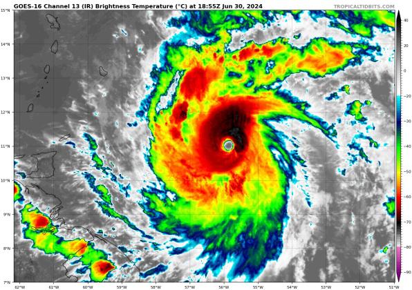
Hurricane Beryl is now a powerful Category 4 hurricane east of Barbados and St. Vincent, where it should bring powerful winds and waves to on Monday. IMAGE/TROPICAL TIDBITS
Hurricane Beryl is now a powerful Category 4 hurricane east of Barbados and St. Vincent, where it should bring powerful winds and waves to on Monday. IMAGE/TROPICAL TIDBITS
Residents of the Windward Islands like Barbados, Grenada Carriacou Island and St. Vincent and the Grenadine Islands and Grenada are feeling the onslaught of a rare June-July major hurricane Monday morning as Hurricane Beryl has arrived with all the winds, rain and storm surge of a Category 4 storm Monday morning.
In the Monday 11 a.m. advisory, the National Hurricane Center said the storm had 140 mph maximum sustained winds and a center low pressure of 956 millibars.
Sunday afternoon, the NHC upgraded Beryl after Hurricane Hunter reconnaissance aircraft found top sustained winds of 130 mph, a bona fide Category 4 storm. Earlier in the day it became a major hurricane, reaching Category 3 at 8 a.m.
To illustrate how fast it's intensified, that was just 39 hours after being named a tropical depression at 5 p.m. Friday afternoon. The NHC reported increased intensity increases with each advisory since; the 11 a.m. and 5 p.m. advisories both reported winds of 130 mph as NHC Forecaster John Cangialosi noted at 5 p.m., "After rapidly strengthening for two days straight, Beryl's intensity appears to have leveled off ... the convection in the eyewall has become a little less symmetric over the past few hours as it has eroded a bit on the south side."
Monday morning, a tropical storm watch covered the entire southern coast of Hispaniola (the Dominican Republic and Haiti), and the government of Jamaica issued a Hurricane Watch for the island, where hurricane conditions are possible by Wednesday. Puerto Rico or Cuba have no watches or warnings up at this time.
The NHC's projected track still has Beryl on a course near Jamaica, the Cayman Islands, and the Yucatan Peninsula of Mexico by Friday. There are no long-range models that bring the storm north of Cuba. However, the NHC is also monitoring a disturbance right on Beryl's heals that could intensify, make it through the Windward Islands by Wednesday, then be near Hispaniola by Friday, giving us something to watch for the next week or so.